

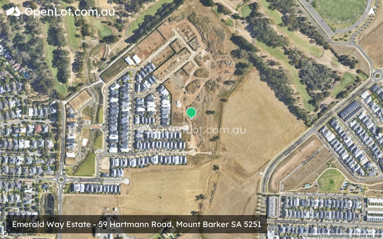
Emerald Way Estate - Mount Barker
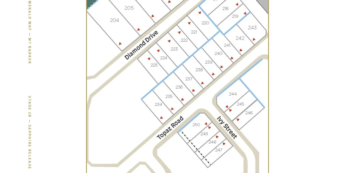
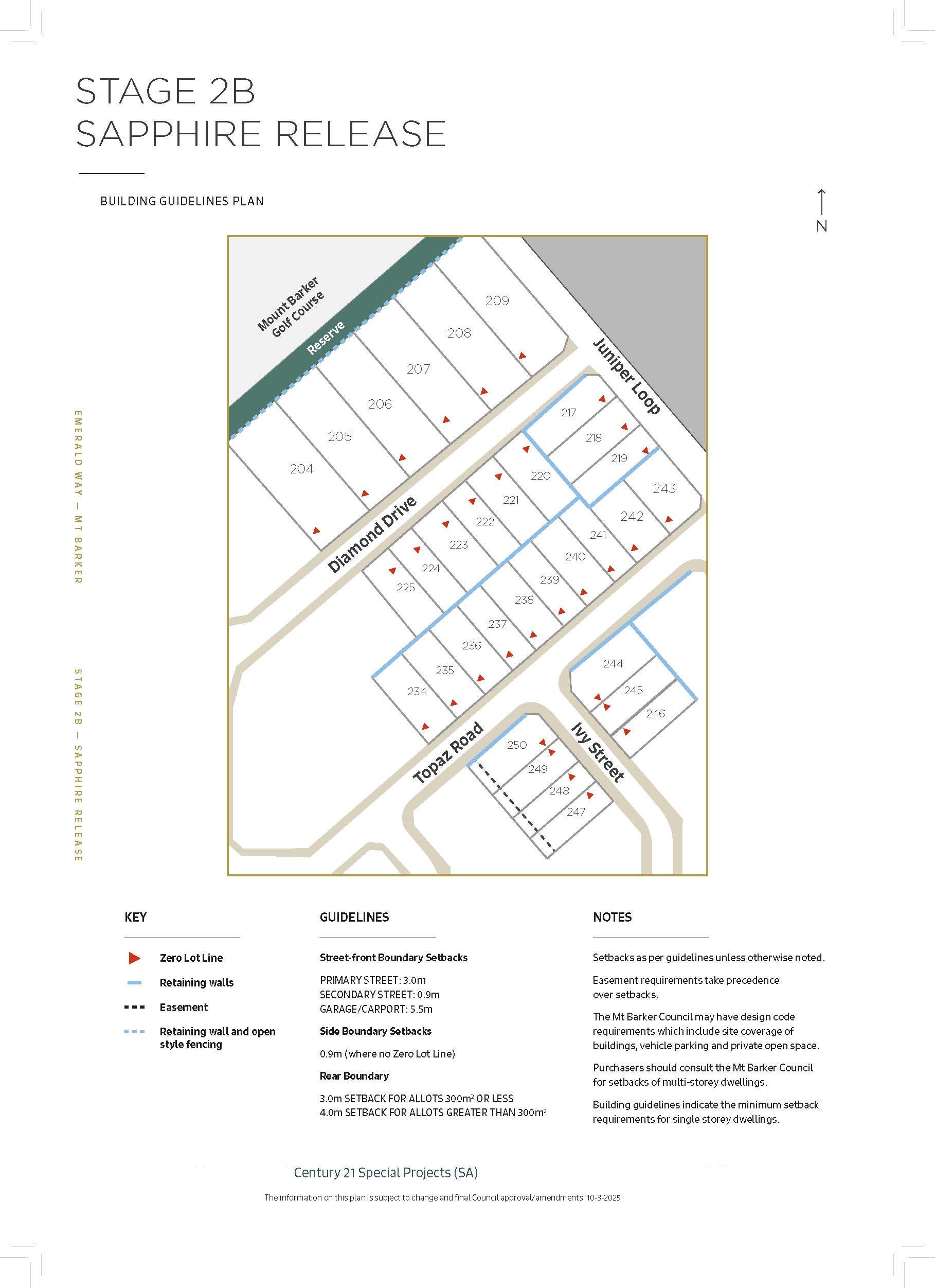
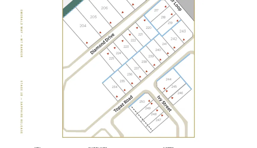
[NEW RELEASE] SAPPHIRE RELEASE (STAGE 2A)! GET IN QUICK!!


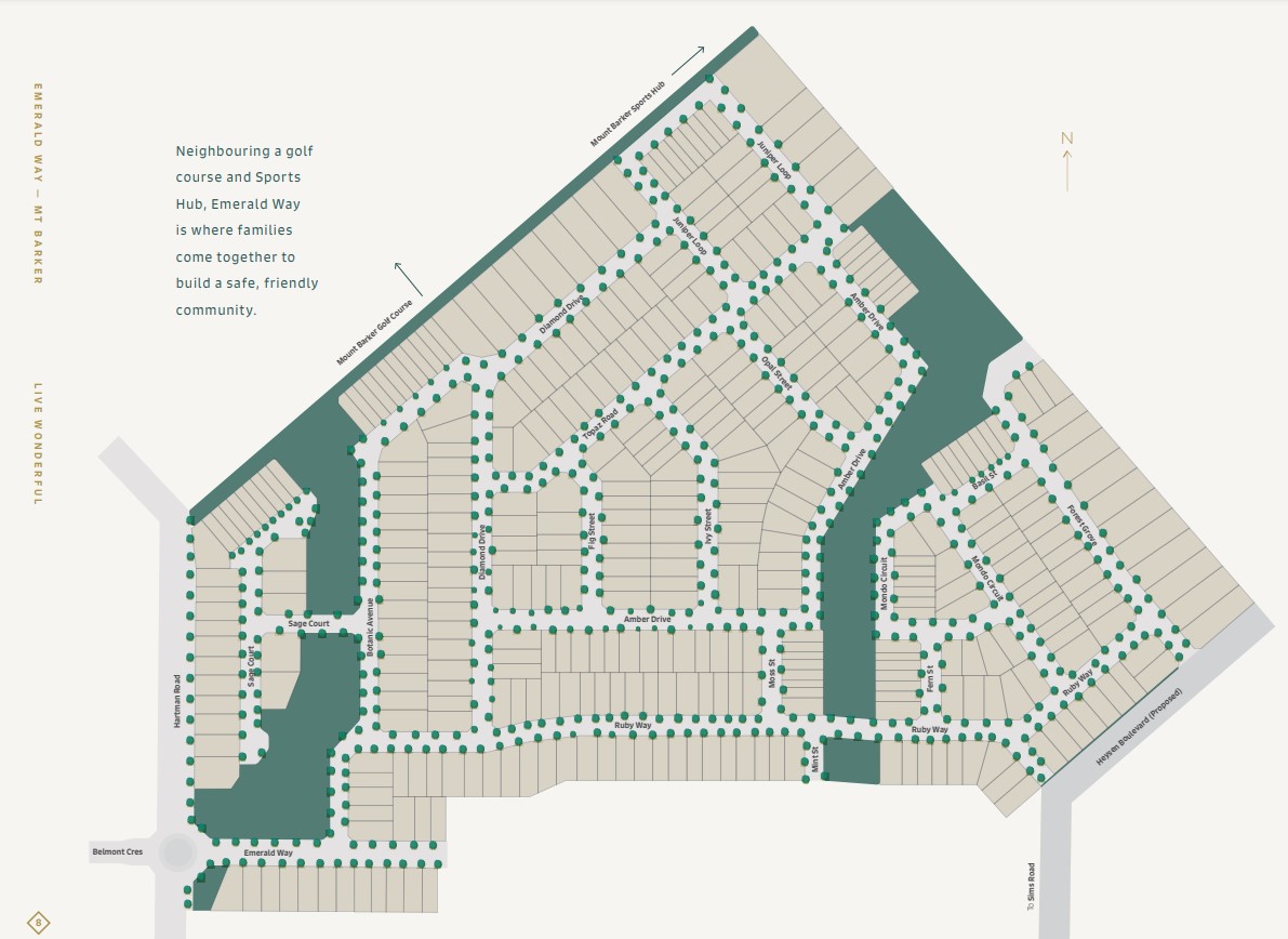
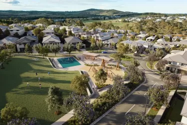
- ✅ A premium estate and a world of its own, Emerald Way is one of the most desired living locations in stunning Adelaide Hills
- ✅ All allotments benched and many with retaining included and fencing included
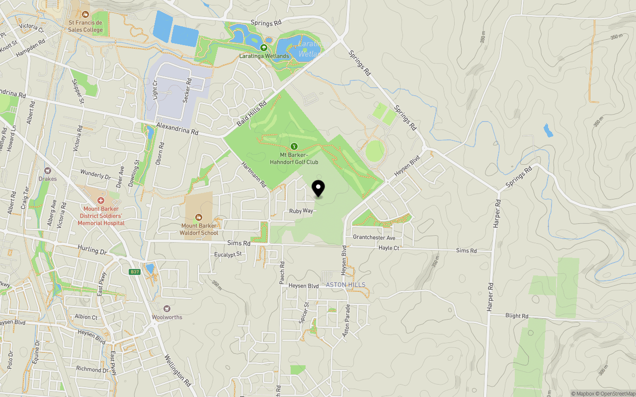
- ✅ Surrounded by Mount Barker’s stunning golf course protecting the open space you desire when living in the Hills
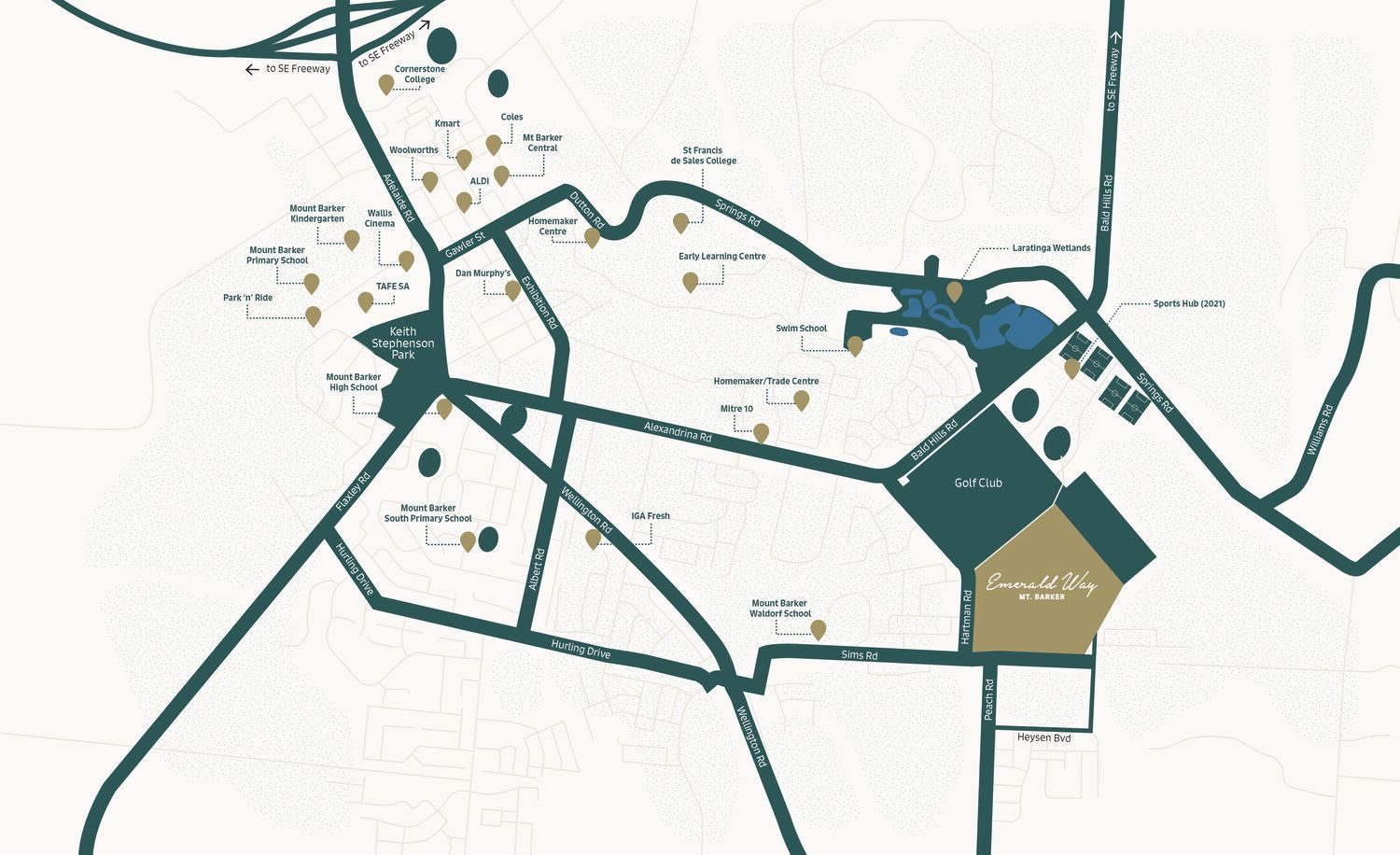
- ✅ Perfectly located 2 minutes from the brand new Drakes Mount Barker & Aston Hills Shopping Centre, future school and medical centre, and a 5-minute drive to Mount Barker Central
- ✅ Connecting to the established Heysen Boulevard for a short drive to the second free-way exit on Bald Hills Road for a seamless drive locally, to the city or regions beyond
- ✅ Brand new multi-million-dollar regional Sports Hub with sports fields, grandstands and state-of-the-art clubrooms right down the garden path.
- ✅ Options of a range of block sizes and diversity in shape and orientation!
- ✅ One of the most desired living locations in the stunning Adelaide Hills
- ✅ Nestled among wineries, breweries and gourmet restaurants, and the Mt Lofty Botanic Garden nearby
- ✅ With 35,000sqm of open space parks with walking trails, playgrounds and community areas
Property types for sale
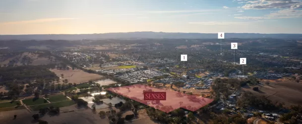
Location & Map for Emerald Way Estate - Mount Barker
Schools near Emerald Way Estate - Mount Barker
3 Land Lots in Emerald Way Estate - Mount Barker
3D Tour of Emerald Way Estate - Mount Barker
6 Display Homes in Emerald Way Estate Display Village - Mount Barker
Emerald Way Mount Barker Video
Overview
This information is estimated by the OpenLot research team. Let us know here to provide up-to-date information about this development.
| Total new homes | |
| Area Size | 22.00 hectares |
| Growth Region | Adelaide Hills Growth Areas |
| City Council | Mount Barker District Council |
| Developer | N/A |
| Project Marketer | Century 21 Special Projects (SA) |
| Creative Agency | WDA Agency |
| Distance to |
Suburb Planning Review in Mount Barker SA 5251
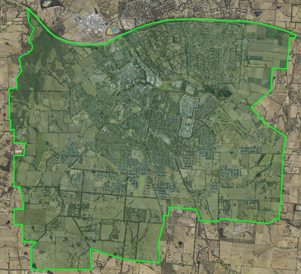
Mount Barker is a local town approximately 37.9 square kilometres in area, forming part of the Mount Lofty Ranges in the Greater Adelaide region of South Australia. Located 33 kilometres south east of Adelaide CBD, the semi-rural township contains a northern urbanised area, large local centre (commercial and retail), large industrial area, residential areas, wetlands, parks and schools. The urbanised area is surrounded by rural land holdings and the agriculture industry.
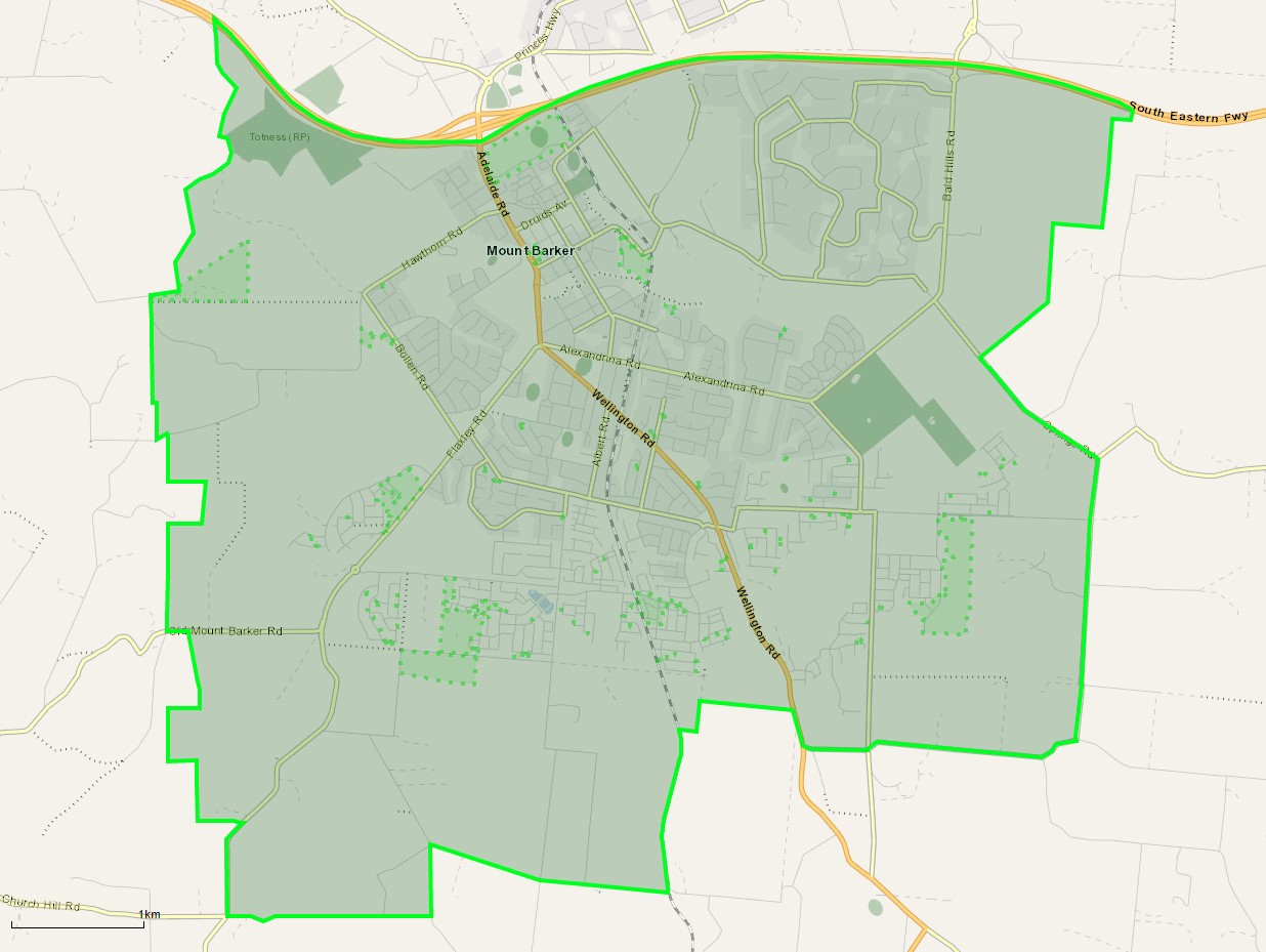
The suburb boundary is located along the Native Avenue, Pinchbeck Firetrack, Fidler Lane, Potts Road, Yunkunga Road and Merritt Road to the south. The South Eastern Freeway is the entire northern boundary, Springs Road, Harper Road and property boundaries to the to the east. Flaxley Road, Haines Firtrack, Liebelt Summer Track and properties boundaries provide the suburb boundary to the west.
A local road network is found throughout Mount Barker, providing access to the surrounding suburbs and the local network of roads. Springs Road and Old Mount Barkers Road provides west and east connections through the centre of the suburb, whilst Wellington Road, Flaxley Road and Bald Hills Road provides north and south connections linking to the major arterial road in proximity.
The northern urban area contains a mix of zoning that facilitates the community needs and services. The neighbourhood zone exists to the south of the business, retail and commercial zoning and provides exiting residential areas of the suburb.
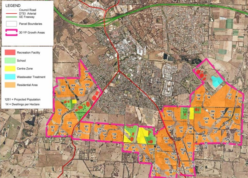
The Master Planned Neighbourhood zoning was rezone under the Mount Barker Urban Growth Areas Development Plan (amendment) declared by the Minister for Planning in December 2010. The growth areas were reflected in the Development Plan prepared by Mount Barker District Council and the 30-Year Plan for Greater Adelaide prepared by the Department of Planning, Transport and Infrastructure for the South Australian State Government.
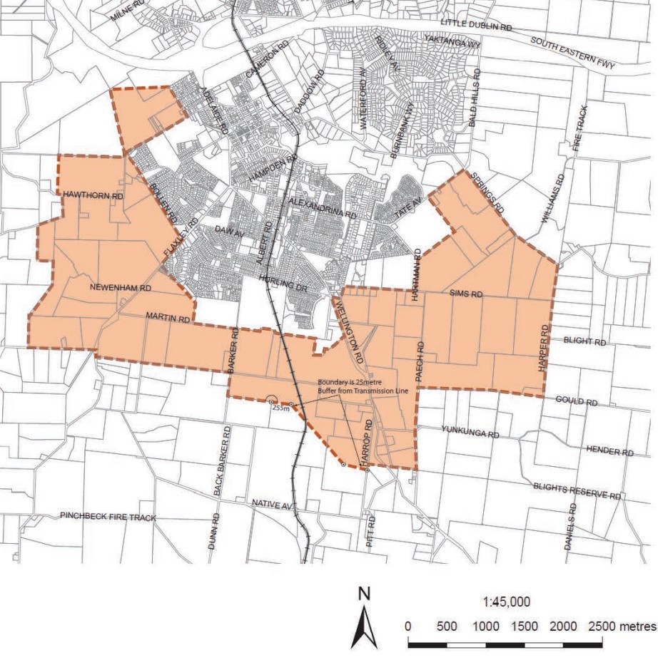
The rezone of Rural land to Residential under the Master Planned Neighbourhood zone affects approximately 1,200 hectares to accommodate a range of housing forms as well as a range of complementary services and activities to meet the needs of future residents. The rezone also included 42 hectares of land within the existing Light Industry Zone.
Mount Barker Submission for Managed Urban Growth
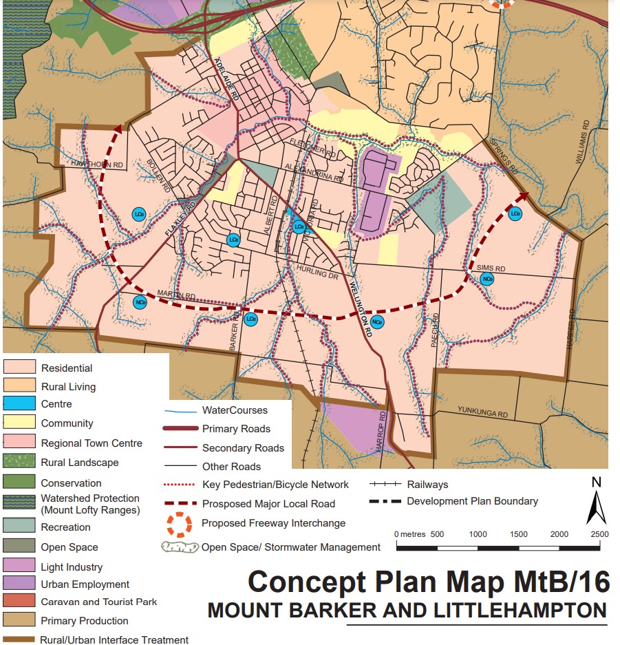
The plan for the next 30 years is the revitalisation of existing neighbourhoods, concentrated new development around transit corridors, and proposed new mixed-use precincts to bring jobs, services and public transport closer to where people live. The Mount Barker Council considered the growth area and provided the following position:
“Over the last ten years the District Council of Mount Barker has been the fastest growing non- coastal Council within Australia, averaging 3 per cent growth per annum. Through this experience Council has learnt invaluable lessons regarding managing and staging rapid growth and wishes to utilise this knowledge in the negotiation and provision of further growth. In the absence of strategies for community building, nor detail or commitment on how the infrastructure, health, education or social needs will be delivered or resourced; the rapid growth proposed in the draft 30 Year Plan threatens each pillar of sustainability and the values shared by the community. Council does not oppose population growth but will only support managed growth which is financially, socially and ecologically sustainable, and clearly resolves the critical issues outlined in Chapter 5 of this Submission”.
Mount Barker Strategic Vision
“The Mount Barker district will be recognised as being highly liveable, prosperous and safe, built from a foundation of community spirit and energy, quality of lifestyle and unique heritage, environment and landscape.” – Mount Barker 2035 District Strategic Plan.
Greater Adelaide Region Growth Area
The population growth in the Greater Adelaide Region area will be 1.97 million people by 2045, which is expected to require a housing growth of 248,000 dwellings. The planning priorities and actions for improving the liveability of residents, a competitive and sustainable region are set down in the 30-Year Plan for Greater Adelaide, 2017 update.
The growth areas will create the opportunity to reduce urban sprawl to the north and south of the elongated metropolitan footprint and the use of urban renewal projects is encouraged to find new spaces and places to live. The City Shape 2043 provides a basis for ongoing discussion with the community about the changing shape of Mount Barker as it grows.
Mount Barker Suburb Summary
Updates for Emerald Way Estate - Mount Barker


Land Price Trend in Mount Barker SA 5251
Below shows the price trend from vacant land sales recorded in Mount Barker SA 5251.
The data and information provided by Terralytics (Aust) Pty Ltd (Terralytics Data) is general in nature and is not intended to constitute professional advice. Read more
It should not be relied upon as a substitute for legal, financial, valuation, or other specialist advice relevant to your specific circumstances.
Terralytics uses commercially reasonable endeavours to ensure the Terralytics Data is current and accurate. However, as the Terralytics Data incorporates information sourced from third parties, Terralytics makes no representation or warranty — express or implied — as to its accuracy, completeness, or currency. To the maximum extent permitted by applicable law, Terralytics excludes all liability for any loss or damage (including consequential loss) arising out of or in connection with reliance on the Terralytics Data, whether arising in contract, tort (including negligence), statute, or otherwise.
Popular Estates near Emerald Way Estate - Mount Barker


Not exactly what you're looking for? Try surrounding suburbs
Wistow SA 5251
2 estates | Mount Barker District Council
6.4km south-east
Meadows SA 5201
1 estate | Mount Barker District Council
14.3km south-west
Nairne SA 5252
3 estates | Mount Barker District Council
7.5km north-east
Woodside SA 5244
1 estate | Adelaide Hills Council
14.8km north
Littlehampton SA 5250
4 estates | Mount Barker District Council
5.1km north
Callington SA 5254
1 estate | Mount Barker District Council
17.0km east
Latest published articles


FAQs about Emerald Way Estate - Mount Barker
The total area for Emerald Way Estate - Mount Barker is 22.00 hectares.
Emerald Way Estate - Mount Barker falls under Mount Barker District Council.
Emerald Way Estate - Mount Barker is 32 km south-east of Adelaide CBD.
Century 21 Special Projects (SA) is the project marketer for Emerald Way Estate - Mount Barker.
Nearby schools for Emerald Way Estate - Mount Barker:
- Mount Barker Waldorf School - 1.1km west
- St Francis de Sales College - 2.5km north-west
- Mount Barker South Primary School - 2.6km west
- St Mark's Lutheran School - 2.6km west
- Mount Barker High School - 2.9km west
- Mount Barker Primary School - 3.5km north-west