🏡 Suburb Profile: Beveridge

Beveridge is within the Mitchell Shire, located 42 kilometres north of Melbourne and the rural-residential township forms part of the Urban Growth Boundary. The Beveridge growth area is approximately 291.97ha, which is located to the south and west of the existing Beveridge Township on either side of the Hume Highway.
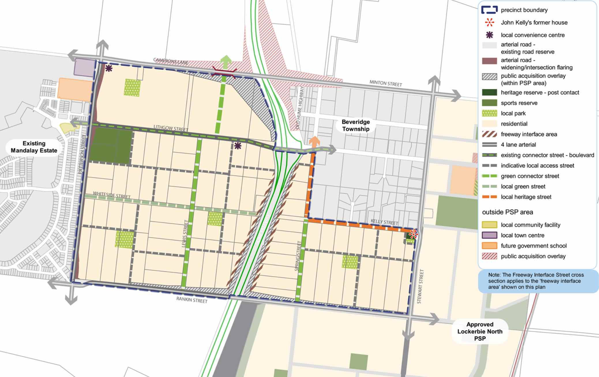
The new suburb is bounded by the existing Mandalay Estate (Patterson Street) to the west, Camerons Lane to the north, Beveridge Township to the north east, Rankin Street to the south and Stewart Street to the east.
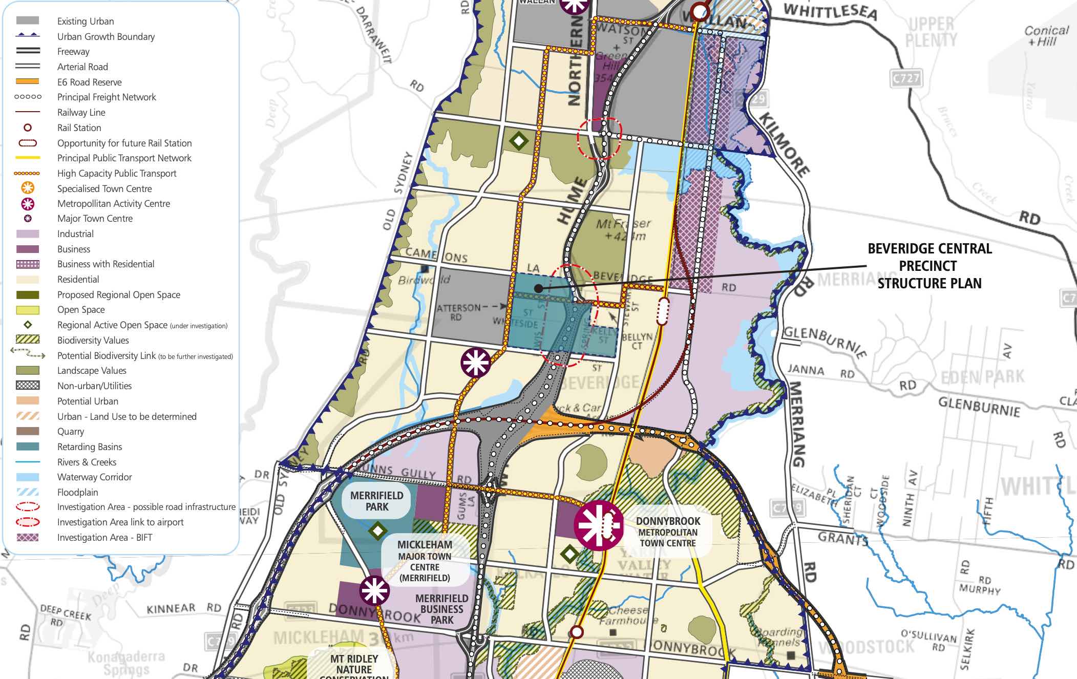
Beveridge Central Precinct Structure Plan – Location map
The Beveridge Central Precinct Structure Plan (PSP) was prepared to guide the redevelopment of two future neighbourhoods separated by the Hume Freeway to provide residential neighbourhoods linked by a network of pathways that connect local parks, reserves and convenience centres.
The eastern side of the Hume Highway will integrate with the existing Beveridge Township and the western side will be connected to the existing Mandalay estate and future precincts of Beveridge North-West and Beveridge South-West.
Beveridge also has a current investigation area to the North West of the existing township. The Victorian Planning Authority (VPA) is preparing a draft Beveridge North West Precinct Structure Plan to introduce the amendment into the Mitchell Planning Schemes. The aim is to have the final decision on the PSP shared publicly by August 2022.
Beveridge Central Precinct Structure Plan – Public Transport
The Beveridge Central PSP was prepared by Victorian Planning Authority (VPA) in consultation with the Whittlesea City Council and Mitchell Shire Council and was approved by the Minister for Planning in December 2018. The decision was officially gazetted in January 2019 under Amendment GC55 to the Mitchell and Whittlesea Planning Schemes.
The Vision of Beveridge
“Beveridge Central is a precinct that builds upon the existing sense of community and history of the Beveridge Township while reinforcing its social and physical connections to newer development occurring in this part of the North Growth Corridor”.
“Beveridge Central is expected to change from a rural-residential community into a well serviced, urban community defined by two future neighbourhoods bisected by the Hume Freeway. The eastern side will have a strong relationship with the existing Beveridge Township and development in the Lockerbie North precinct; the western side connecting to the future Beveridge North-West and Beveridge South-West precincts and existing Mandalay estate. There is a focus on creating a high amenity landscape character by featuring extensive landscaping opportunities and green streets within the existing wide road reserves”.
“A cycling and pedestrian path network along streets will connect key destinations such as local parks, the sporting reserve and convenience centres. Highlighting the precinct’s heritage features provides a sense of place for future residents through the preservation and enhancement of Aboriginal and post-contact heritage places and provides mechanisms to ensure the ongoing protection of these places”.
“To service the needs of future residents the precinct will be connected to social and community infrastructure in immediate neighbouring areas. The neighbourhood infrastructure needs of the community will be largely met within the precinct itself, with high quality open spaces and a sports field. Shopping and commercial services will be readily accessible immediately adjacent to the precinct in new town centres in Mandalay and Lockerbie North, with small scale retail needs provided by two local convenience centres within the precinct”.
“In the longer term, the precinct will be accessible to higher-order services, shopping and jobs at the Beveridge Major Town Centre to the southeast of the precinct. Beveridge Central Precinct will have strong transport connections to key destinations via the Hume Freeway, a potential new railway station at Beveridge, and the future Outer Metropolitan Ring (OMR) road, approximately 2km to the south”.
Featured Developments in Beveridge
Beveridge Suburb Summary
References