
$644,400
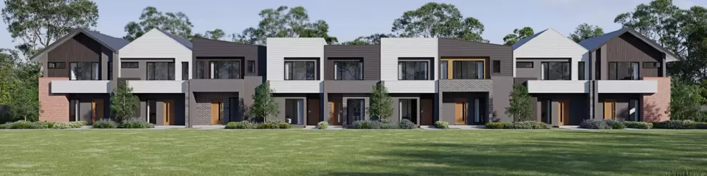
Lot 233 @ Fernlea Estate


Fernlea is more than just a new address – it’s the next chapter in a proud family legacy. Fernlea offers a new kind of neighbourhood where connection, community and possibility come together. This is a place to grow, belong, and put down your roots.
Because community isn’t something you visit. It’s something you come home to.
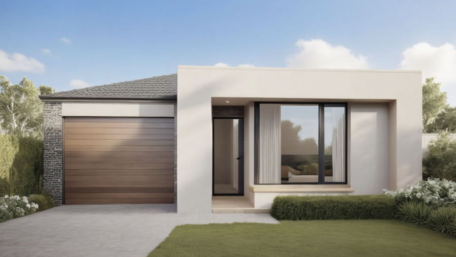
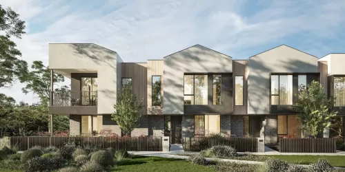
Theis package from Turnkey Homes includes:
✓ FULL TURNKEY MOVE IN READY INCLUSIONS AND FIXED PRICE
✓ INCLUDES ALL DEVELOPER & COUNCIL REQUIREMENTS
✓ NCC COMPLIANT CONSTRUCTION
✓ 7-STAR ENERGY-EFFICIENT, ALL-ELECTRIC HOME
✓ 40MM CAESARSTONE® BENCHTOPS TO KITCHEN
✓ BOSCH APPLIANCES, INCLUDING DISHWASHER
✓ 20MM CAESARSTONE® BENCHTOPS TO BATHROOM & ENSUITE
✓ STEP-FREE TILED SHOWER BASES
✓ HIGH CEILINGS THROUGHOUT (2590MM)
✓ TIMBER LAMINATE FLOORING TO MAIN AREAS
✓ DELUXE CARPET TO BEDROOMS
✓ LED DOWNLIGHTS THROUGHOUT
✓ ROLLER BLINDS & FLYSCREENS
✓ REVERSE CYCLE SPLIT SYSTEMS TO LIVING AREA & BEDROOM
✓ DOUBLE GLAZED WINDOWS THROUGHOUT
✓ FRONT & REAR LANDSCAPING INCLUDED
*When you contact the number in this listing, your number, enquiry, call duration and time will be collected on behalf of realestate.com.au and provided to Core Projects Pty Ltd (Core Projects) to respond to your enquiry. For further details, see our Privacy Policy.
Prices are subject to change without notice and are exclusive of GST. Dates for Titles are estimated only and are subject to change. While every care is taken in preparing this listing, Core Projects makes no representations or warranties as to the currency or accuracy of the information which is subject to change at any time. The recipient must make its own independent enquiries to verify the content of this document. Core Projects will not be liable for any reliance the recipient makes on the content.
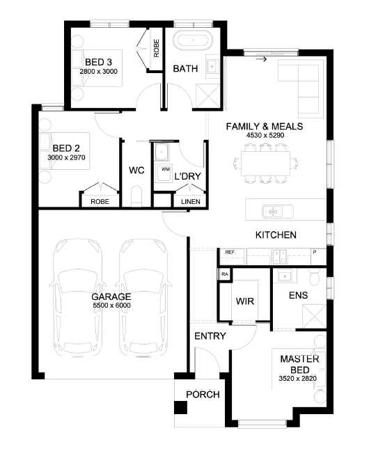
Property overview
- Beds
- 3
- Baths
- 2
- Car Spaces
- 1
- Land area
- 275m²
- Builder
- Turnkey Building Group
Local information in Clyde VIC 3978
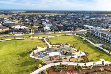
22 Land Lots in Fernlea Estate - Clyde
10 House and Land Packages in Fernlea Estate - Clyde
Suburb Planning Review in Clyde VIC 3978
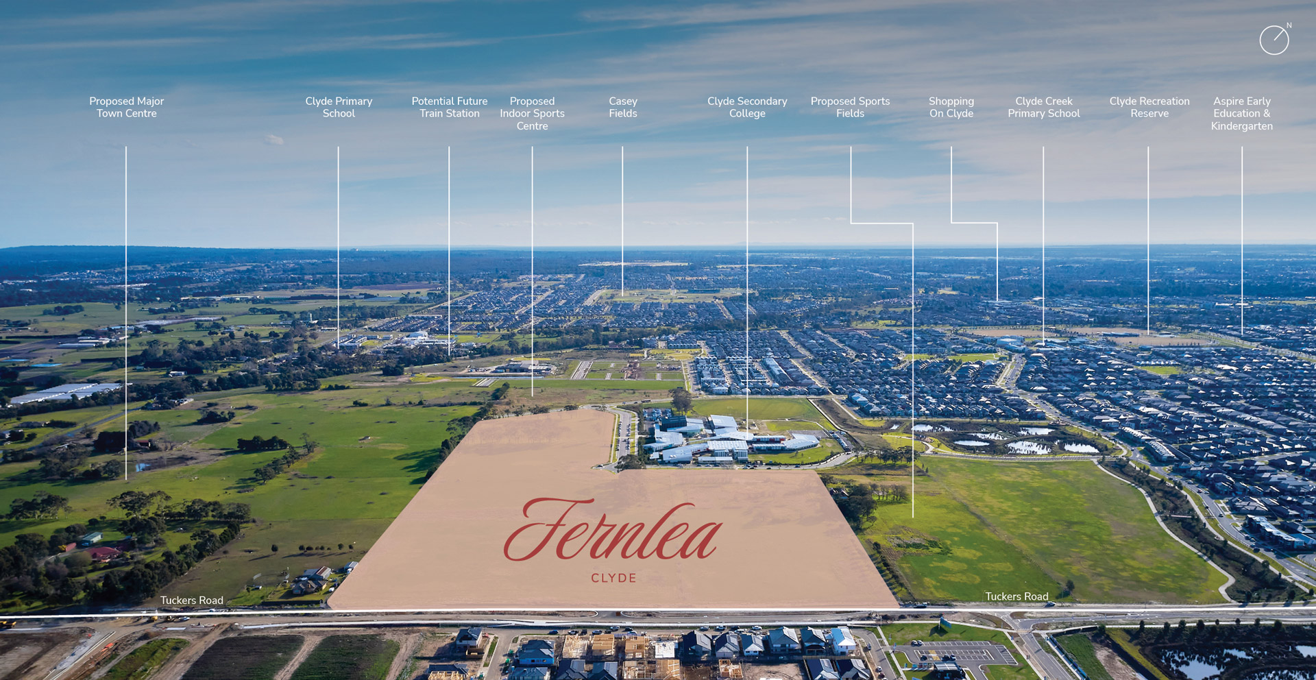
Clyde is with the City of Casey located 48 kilometres South-East of Melbourne, which contains a rural-residential township that forms part of the Urban Growth Boundary. The Clyde growth area is approximately 1,154 ha, which is located on either side of the Pattersons Road.
The new suburb is bounded by Clyde-Five Ways Road to the west, Pound Road and Bells Road extension to the east, Hardys Road to the north and Ballarto Road to the south.
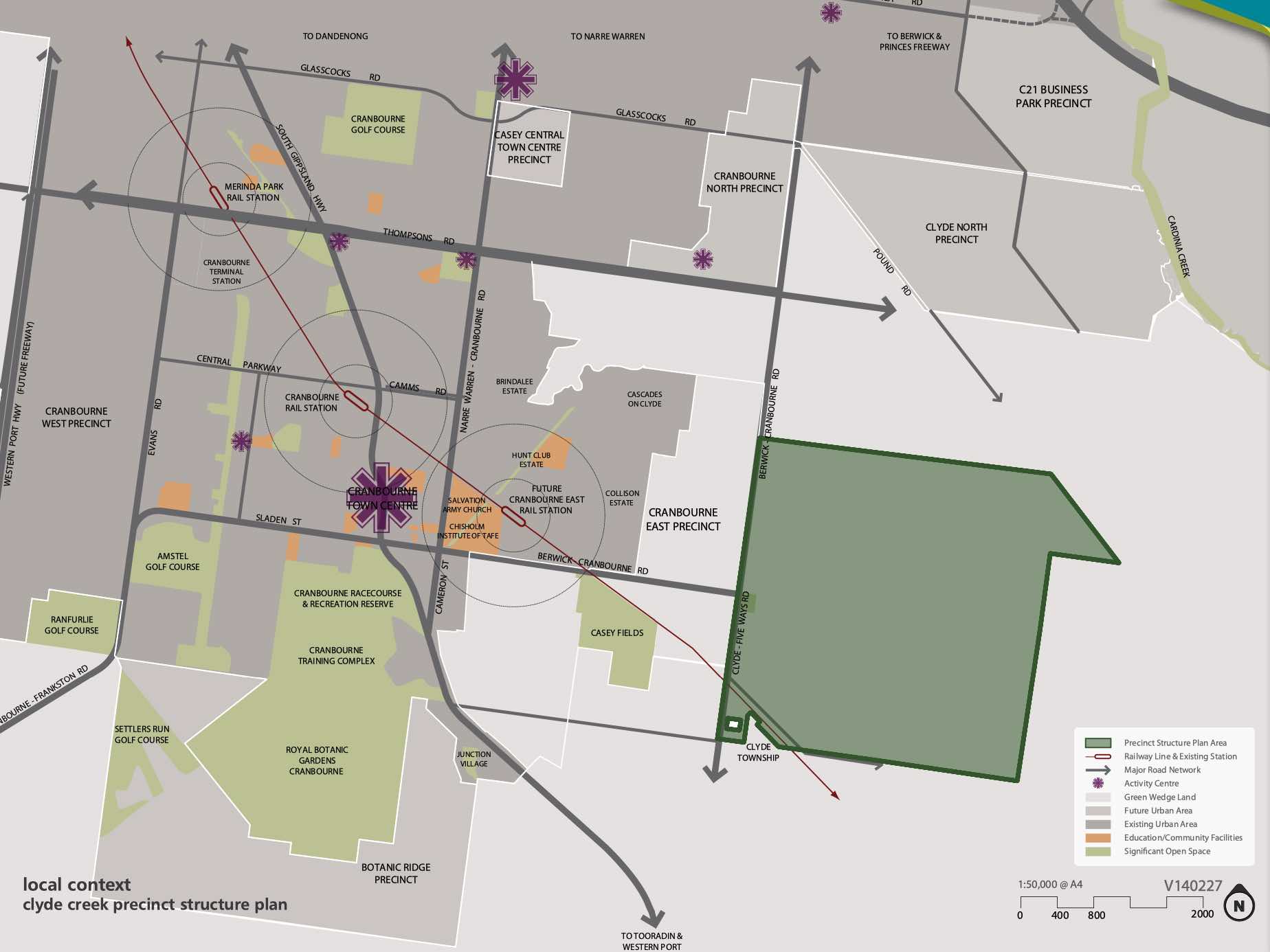
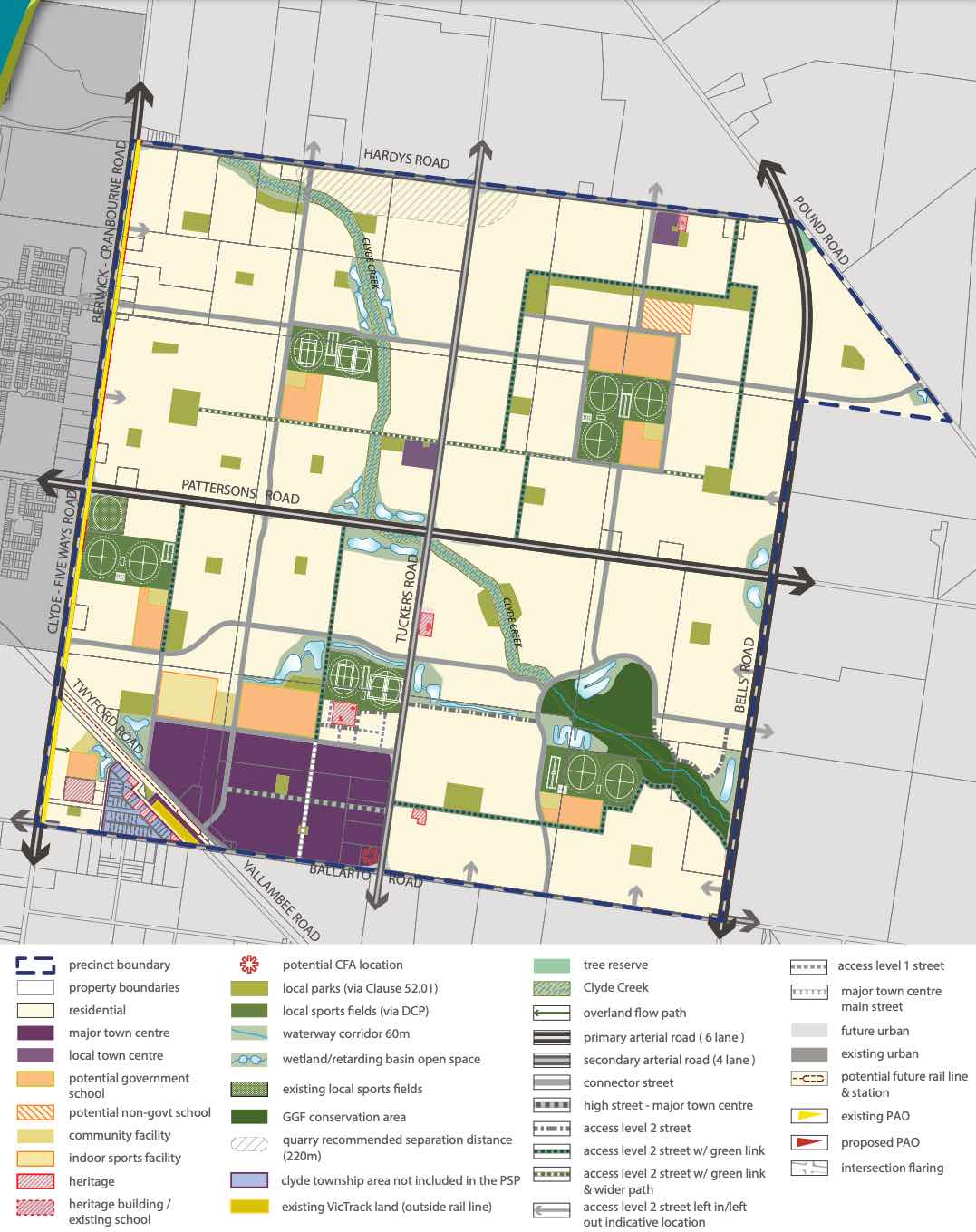
The Clyde Creek Precinct Structure Plan (PSP) was prepared to guide the future community, visitors and workers within the area. The PSP seeks to provide access to services, recreation, employment, shopping and transport infrastructure necessary to support quality of lifestyle and a mix of affordable housing.
The conservation and enhancement of the significant biodiversity area of the Clyde Creek corridor have been recognised, which integrates the stormwater design and open space. A protected species of the Growling Grass Frog has been provided ponds and foraging areas along the Clyde Creek corridor and cultural heritage sites.
Clyde also has other Precinct Structure Plan areas to the north of the existing township. The Victorian Planning Authority (VPA) has prepared a Clyde North PSP that was approved by Minister for Planning in November 2011 through Amendment C186 to the Casey Planning Scheme.
The Clyde Creek Precinct Structure Plan PSP was prepared by Victorian Planning Authority (VPA) in consultation with the Casey City Council and was approved by the Minister for Planning in November 2014. The decision was officially gazetted in October 2014 under Amendment C186 to the Casey Planning Scheme, then further amended in October 2015.
The Vision of Clyde Creek
“Clyde Creek is planned to be a community where a distinct urban form, characterised by a grid of high quality streets, is complemented by an extensive natural creek environment and park network. The Clyde Major Town Centre, planned immediate to the north of the potential future Clyde railway station, will deliver extensive services and facilities to the surrounding residential area.”
“Clyde Creek will be a place that residents and businesses are proud to call home, a place of significant housing choice, catering for a diversity of people, and a connected community through public transport, road-trail networks and integrated community hubs.”
“Significant biodiversity within the Clyde Creek corridor has been recognised through the conservation and enhancement of the Growing Grass Frog Category 1 habitat area. The prominent landform of the precinct, Clyde Creek, will form the key environmental, recreational and community spine of the future suburb. The topography of the precinct provides for attractive views and vistas.”
“Heritage values - both aboriginal and cultural heritage and post-contact heritage sites - have been identified and incorporated into the future urban structure of Clyde Creek Precinct.”
Benefits of Clyde Creek
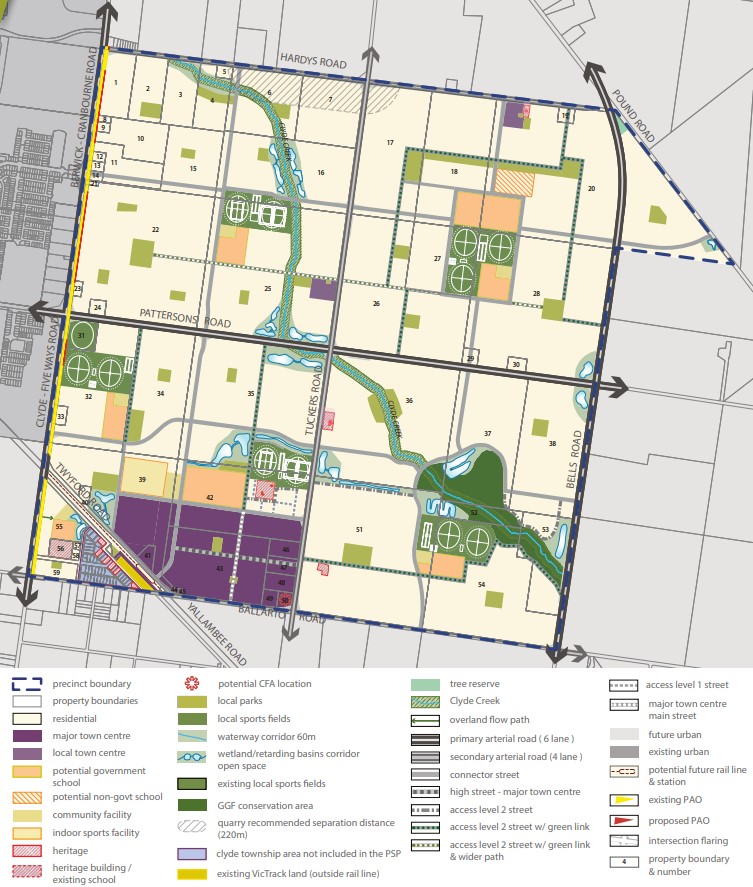
The existing zoning will be amended to provide for Urban Growth Zones, that will provide for a future urban structure and future development. The Clyde Creek Precinct Structure Plan provides for a diversity of streetscape, open space, local character and protection of the Clyde Creek Conservation Area that traverses the precinct.
Existing and proposed sports fields and parks are strategically located within the new residential areas. The major and minor town centre areas provide for social, retail and community infrastructure, with the largest located to the south west corner of the Precinct Structure Plan.
The Precinct Structure Plan provides the planning framework to facilitate the new mixed use community, new schools, sports and recreation areas and protect Clyde Creek.
Transportation in Clyde Creek
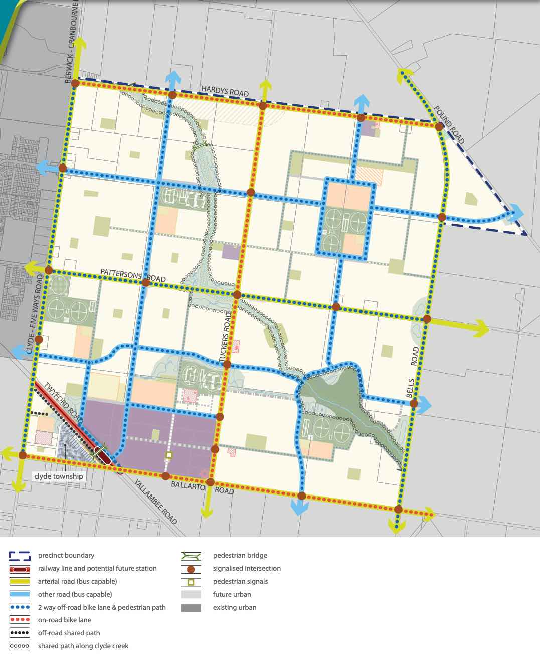
Clyde Creek will be connected to public passenger transport, with a future train station to be built in proximity to the south west of the Clyde Township and the passenger train service will connect to Melbourne CBD.
The suburb will include a network of shared paths, linking the local parks and a new road network. A road network including a 6 lane (primary arterial) road along Pattersons Road and 4 lane (second arterial) road along Tuckers Road to facilitate vehicle access to the surrounding growth areas and Clyde North. Access to Berwick – Cranbourne Road to the west will provide a direct connection to the Princes Freeway, access to Melbourne CBD or eastern Victoria.
Clyde Creek Suburb Summary
References
Victoria Planning Authority – Planning Schemes
Victoria Planning Authority – Clyde Creek PSP
Estate overview
This information is estimated by the OpenLot research team. Let us know here to provide up-to-date information about this development.
| Total new homes | |
| Area Size | 15.21 hectares |
| Growth Region | Melbourne South East Growth Corridor |
| City Council | Casey City Council |
| Developer | 75 Tuckers Road Project Management Pty Ltd |
| Project Marketer | Core Projects |
| Creative Agency | Equality Media |
| Distance to |
Updates for Fernlea Estate - Clyde

Nearby schools in Fernlea Estate - Clyde
There are 6 schools registered in this area on ACARA 2024
FAQs about Fernlea Estate - Clyde
75 Tuckers Road Project Management Pty Ltd is the developer behind Fernlea Estate - Clyde.
Fernlea Estate - Clyde consists of 92 homes.
The total area for Fernlea Estate - Clyde is 15.21 hectares.
Fernlea Estate - Clyde falls under Casey City Council.
Fernlea Estate - Clyde is 48 km south-east of Melbourne CBD.
Core Projects is the project marketer for Fernlea Estate - Clyde.
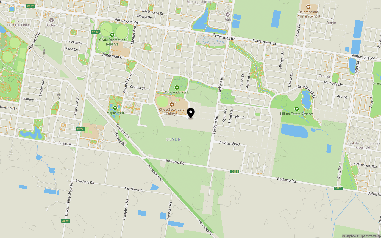
Nearby schools for Fernlea Estate - Clyde:
- Clyde Secondary College - 284m north-west
- Clyde Creek Primary School - 1.2km north-west
- Clyde Primary School - 1.3km west
- Ramlegh Park Primary School - 1.6km north
- St Thomas the Apostle Catholic Primary School - 2.6km north-west
- Topirum Primary School - 3.0km north-east
Land Price Trend in Clyde VIC 3978
Below shows the price trend from vacant land sales recorded in Clyde VIC 3978.
The data and information provided by Terralytics (Aust) Pty Ltd (Terralytics Data) is general in nature and is not intended to constitute professional advice. Read more
It should not be relied upon as a substitute for legal, financial, valuation, or other specialist advice relevant to your specific circumstances.
Terralytics uses commercially reasonable endeavours to ensure the Terralytics Data is current and accurate. However, as the Terralytics Data incorporates information sourced from third parties, Terralytics makes no representation or warranty — express or implied — as to its accuracy, completeness, or currency. To the maximum extent permitted by applicable law, Terralytics excludes all liability for any loss or damage (including consequential loss) arising out of or in connection with reliance on the Terralytics Data, whether arising in contract, tort (including negligence), statute, or otherwise.
Popular Estates near Fernlea Estate - Clyde


Not exactly what you're looking for? Try surrounding suburbs
Clyde North VIC 3978
54 estates | Casey City Council
1.9km north
Cranbourne VIC 3977
5 estates | Casey City Council
6.3km north-west
Botanic Ridge VIC 3977
5 estates | Casey City Council
6.1km west
Junction Village VIC 3977
5 estates | Casey City Council
3.5km west
Cranbourne East VIC 3977
25 estates | Casey City Council
3.6km north-west
Tooradin VIC 3980
1 estate | Casey City Council
7.7km south-east


