
$627,500
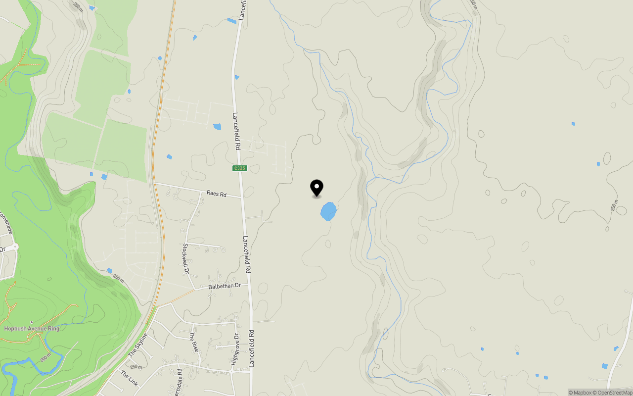
Lot 129 @ Rockcliffe Estate


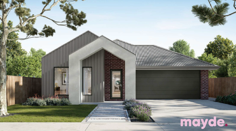
The Carter from Mayde Includes:
# Price inclusive of FHOG
# Colourbond steel roof
# 20mm mineral surface benchtops to kitchen and bathrooms
# All electric appliances and 3.5kw solar included
# Water resistant laminate and uprated carpet throught
# LED downlights to all living areas
# Minimum two split systems and entire home heating
# Fixed site costs and developer guidelines
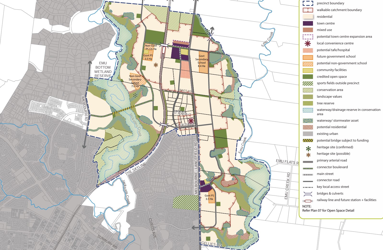
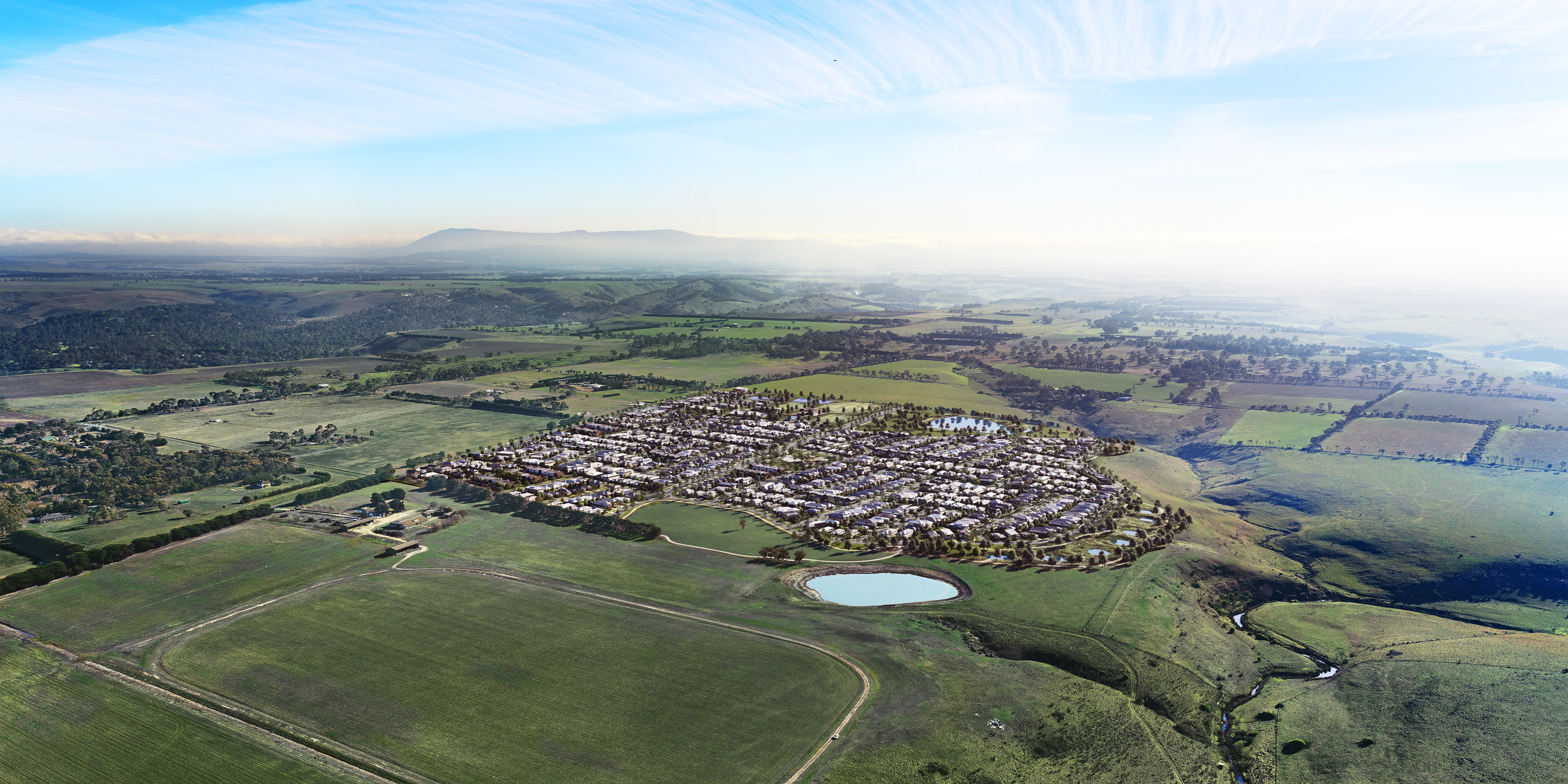
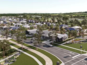
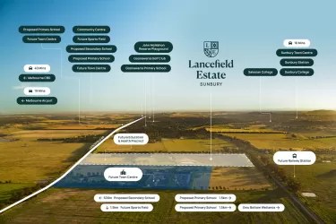
Defined by wide, tree-lined streets and homes oriented for optimal solar access, Rockcliffe offers a walkable, light-filled neighbourhood designed to connect residents with nature. A central park, along with an extensive network of pocket parks, wetlands and conservation reserves, ensures that 95% of homes are within a five-minute walk to green space.
Designed with families in mind, the community will also feature a future proposed Government secondary school, supporting long-term liveability.
Delivered by Pask, with over 55 years of experience creating established communities including The Maples and Providence Greenvale, Rockcliffe presents a rare opportunity to secure land in one of Sunbury’s most naturally connected settings.
For more information contact the Rockcliffe sales team on 1300 635 953 or visit the sales suite at 280 Lancefield Road, Sunbury, open Wed – Sat, 11am to 5pm.
*When you contact the number in this listing, your number, enquiry, call duration and time will be collected on behalf of realestate.com.au and provided to Core Projects Pty Ltd (Core Projects) to respond to your enquiry. For further details, see our Privacy Policy. Prices are subject to change without notice and are exclusive of GST. Dates for Titles are estimated only and are subject to change. While every care is taken in preparing this listing, Core Projects makes no representations or warranties as to the currency or accuracy of the information which is subject to change at any time. The recipient must make its own independent enquiries to verify the content of this document. Core Projects will not be liable for any reliance the recipient makes on the content.
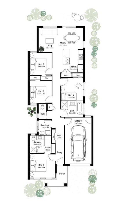
Property overview
- Beds
- 4
- Baths
- 2
- Car Spaces
- 1
- House area
- 15m²
- Land area
- 294m²
- Builder
- Mayde Homes
- Home Design
- Carter
Local information in Sunbury VIC 3429
11 Land Lots in Rockcliffe Estate - Sunbury
13 House and Land Packages in Rockcliffe Estate - Sunbury
Suburb Planning Review in Sunbury VIC 3429
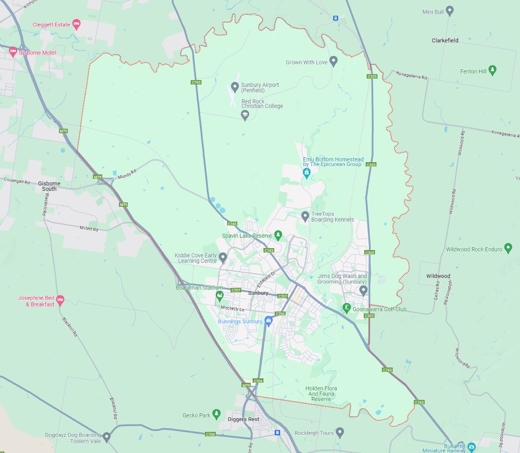
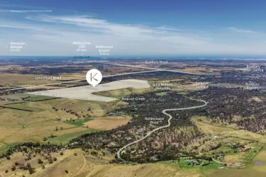
Sunbury is approximately 22.1 square kilometres within the City of Hume, a largely rural location to the north-west of Melbourne’s outer suburbs of the Urban Growth Boundary and logical expansion of the former Sunbury township. The suburb is located 38 kilometres north-west of Melbourne CBD.
Sunbury became recognised as part of Greater Melbourne following the Victorian Government's resolution in 2009 to expand the urban growth boundary in 2011. This decision incorporated the region into the Melbourne Urban Area, specifically as the north-western periphery of Greater Melbourne.
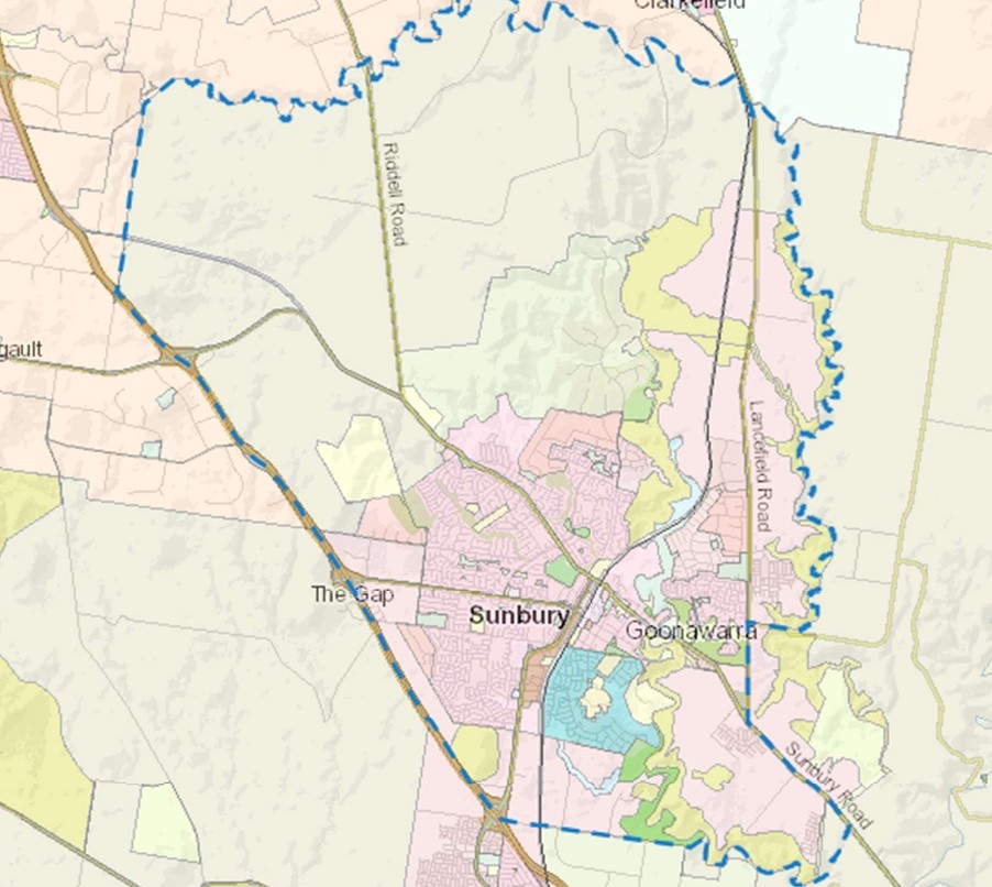
The suburb boundary is located along Jacksons Creek corridor to the North, with Emu Creek and Lancefield Road making up the eastern boundary. Watsons Road and Jacksons Creek provide the small southern boundary, with property boundaries and Calder Freeway providing the western boundary.
Riddell Road, Vineyard Road and Sunbury Road provide local road access (north to south), along with Gap Road and Mundy Road provide local road access (East to West) throughout Sunbury linking to the Calder Freeway interchange found to the eastern boundary of the township. An additional southbound off-ramp is found in three locations along the eastern boundary. The interchanges allow direct access for anyone travelling through the region.
The suburb of Sunbury is a large established suburb, providing a range of residential settlement patterns, small-large property sizes, townhouses and multiple dwellings. A large northern portion and small southern pocket of the suburb is still rural land, with hilly terrain and waterway corridor located throughout. Sunbury slowly redeveloping, with existing local retail centres, supermarkets, small airport, train station, services, schools and recreational areas supporting the growth.
Melbourne 2030 (2008 Update) - Victorian Government
In 2002 the Victorian Government's blueprint for managing long-term growth in the surrounding region. The 2008 release of updated population projections in "Victoria in Future 2008" prompts a revaluation of development strategies, ensuring Melbourne remains adaptable. Acknowledging an inevitable population surge, "Melbourne @ 5 million" emphasises readiness and focuses on job creation and service provision in key areas.
The update prioritises preserving liveability and enhancing quality of life. It targets growth towards Melbourne's north and west while exploring expansion possibilities. Moreover, it encourages collaboration with councils to identify suitable redevelopment sites, underscoring the importance of community support for Melbourne's evolution as a top-tier city.
Key Facts:
Melbourne 2030 (2002): Established the Urban Growth Boundary (UGB) to manage expansion
UGB Purpose: Directs growth to areas with infrastructure while protecting land and environment.
2010 UGB Review: Accommodated 600,000 new dwellings, primarily in north and west
Environmental Assessment: rigorous studies and Commonwealth approval to protect natural features.
Funding Infrastructure: Introduction of Growth Areas Infrastructure Contribution (GAIC) and improved Development Contribution Plans (DCP).
2012 Expansion: Added 6,000 hectares to UGB based on recommendations
Outer Melbourne Northern Suburbs Upgrade
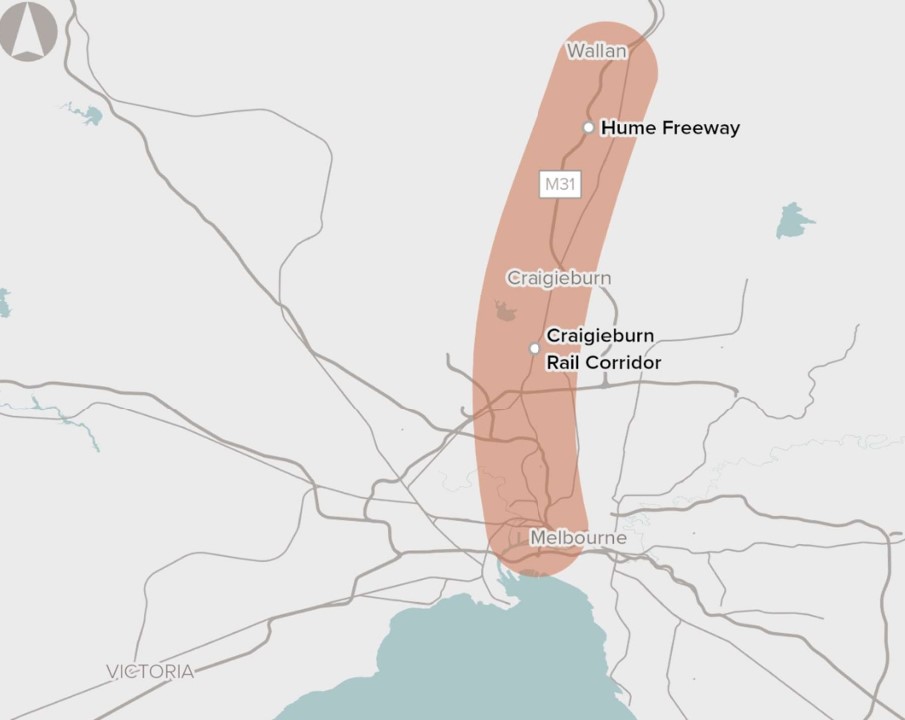
Infrastructure Australia in 2016 identified the need to improve urban transport networks between Melbourne's Outer Northern Suburbs and the CBD, marking it as crucial within a medium-term timeframe of 5-10 years. The proposal aims to address pressing transportation challenges due to rapid growth in the Northern Growth Corridor. With projections indicating significant population and employment increases by 2031, existing road and rail infrastructure faces strain, leading to anticipated congestion and delays along the Hume Freeway and the Seymour Line.
Recognising the urgency, the Victorian and Australian Governments are collaborating on a comprehensive strategy integrating road and rail network planning. Through various projects and proposed reforms outlined in Victoria’s infrastructure strategy 2021-2051, efforts are underway to alleviate congestion and enhance transportation services in the corridor. Emphasising the need to explore diverse options, including infrastructure upgrades and reforms, this proposal seeks to meet the transportation needs of Melbourne's outer northern suburbs' growing population and employment hub.
Growth Corridor Plans
The Precinct Structure Plans (PSPs) complement the broader land use framework outlined in the Growth Corridor Plans. PSPs are detailed planning documents that guide development within specific precincts, ensuring they align with the overarching goals of the Growth Corridor Plans. Developed through a consultative process involving stakeholders, PSPs provide a strategic blueprint for neighbourhood development.
In 2012, the Growth Areas Authority (GAA) in collaboration with local councils, PSPs defined the pattern for neighbourhood growth, ensuring cohesion and sustainability over time. They play a crucial role in creating attractive, convenient, and sustainable local communities within the broader growth framework.
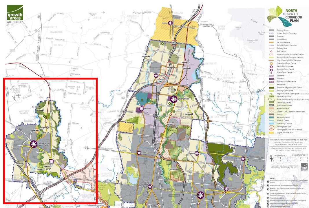
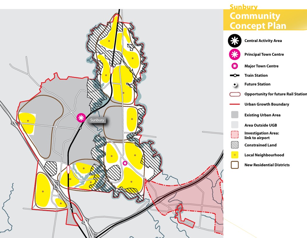
Northern Growth Corridor Plan (Sunbury Shown)
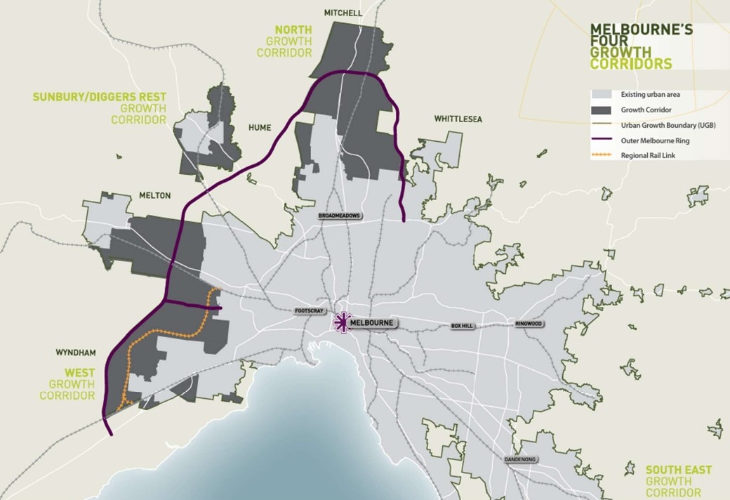
Melbourne's north will undergo significant transformation, driven by a diverse socio-economic landscape and a burgeoning economy, supported by key infrastructure like Melbourne Airport and major transport arteries. The Northern Growth Corridor Plan aims to accommodate 260,000 residents and generate 83,000 jobs, focusing on advanced manufacturing, logistics, and the knowledge economy. The plan prioritizes preserving natural features, improving public transport, and developing new town centres to sustainably support the area's growth, alongside initiatives to provide diverse housing options for evolving community needs.
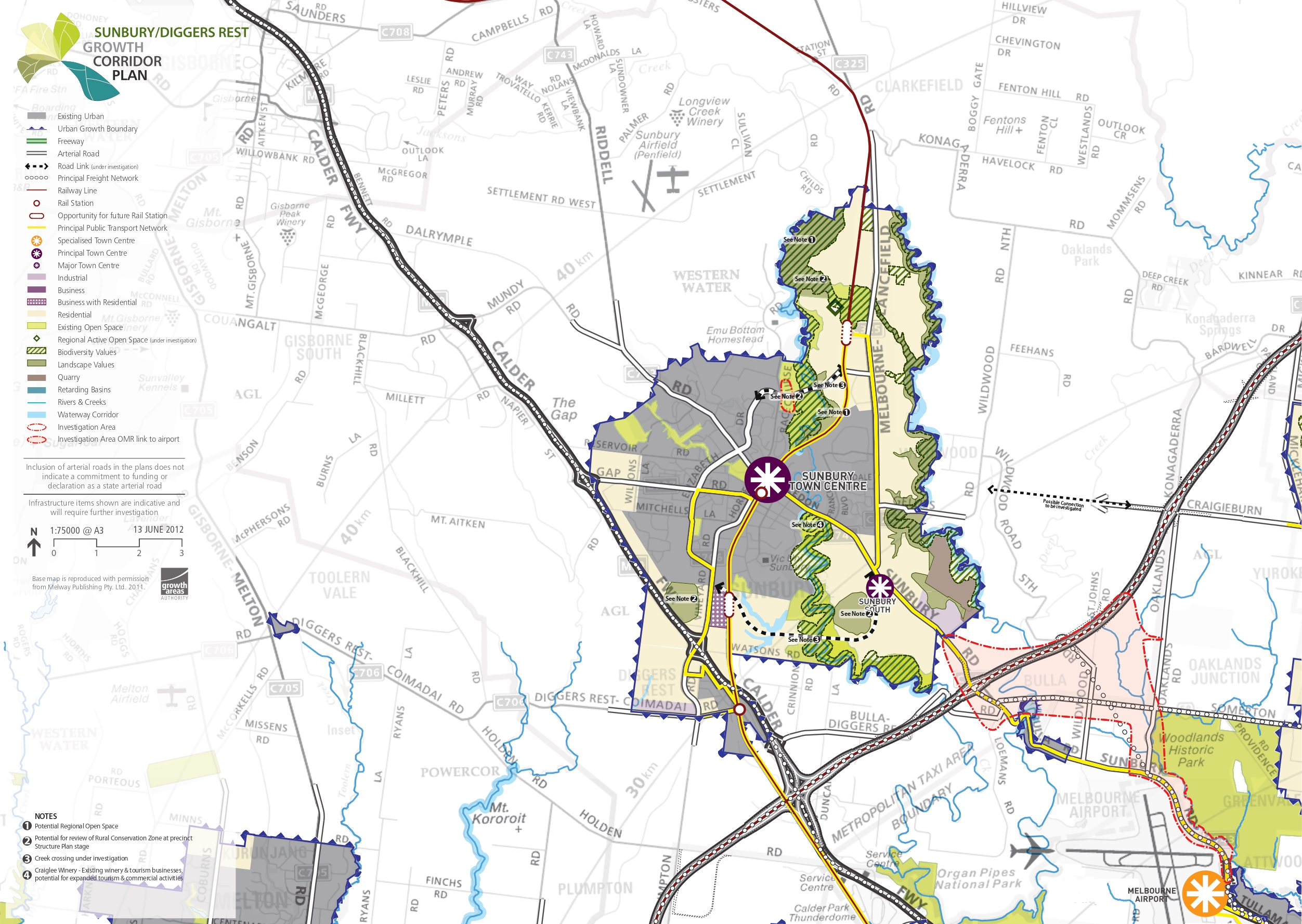
Sunbury/Diggers Rest Growth Corridor Plan
Sunbury and Diggers Rest are nestled amidst rolling hills, tree-lined creek valleys, and open spaces. The Growth Corridor Plan anticipates accommodating a population of over 71,000 people and 10,000 jobs in the area. The well-established Sunbury town centre caters to residents and enjoys its 'country town' ambience, while also benefiting from proximity to major employment hubs like Melbourne Airport and Broadmeadows. Accessibility to Melbourne's CBD is facilitated by the Calder and Tullamarine Freeways, with further enhancements expected on the electrified Sunbury rail line.
However, limited local employment opportunities lead to pressure on transportation networks during peak hours. Sunbury's layout, shaped by plateaus and creek lines, gives rise to distinct urban areas connected to the main centre via arterial roads, though congestion is common due to restricted east-west connections.
Future development in Sunbury and Diggers Rest must address several key issues:
Improving local transport links, including creek crossings and main approach roads
Enhancing the range of local jobs and services
Strengthening the Sunbury town centre and providing quality local access
Increasing Diggers Rest's population to support a wider range of amenities
Preserving and enhancing the semi-rural and natural environment
Establishing accessible open spaces, particularly along Jacksons and Emu creeks
Vision of Sunbury and Diggers Rest
“Sunbury and Diggers Rest will develop as a highly attractive and liveable regional city linked to but distinct from the metropolitan area. Its distinctive creek environs, hills and rural hinterland provide an attractive landscape setting for the township, which will be maintained and enhanced. The environmental and cultural heritage values of Jacksons and Emu Creeks will be protected and enhanced, and community access to these areas will be improved over time.
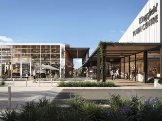
The Sunbury Town Centre will grow in importance as a regional hub and will be complemented by a series of smaller town centres that meet the local shopping and other needs of residents. Diggers Rest will grow to become a more self-contained neighbourhood, supported by a Local Town Centre, open space and community facilities. Transport access will improve over time, with the extension and electrification of rail services and extensions to the local bus networks, as well as road upgrades that improve connectivity within and to the town centre.
These upgrades will better link the community to employment areas beyond Sunbury, including Melbourne Airport, the Craigieburn employment corridor and opportunities proposed in the Melton corridor. Additional employment opportunities will be provided within the town over time, within the Sunbury Town Centre, local centres and new local industrial precincts”.
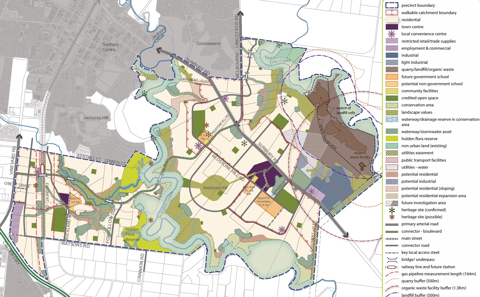
Precinct Structure Plans
The Growth Areas Authority, in collaboration with the Hume City Council, government agencies, service authorities, and key stakeholders, has developed the Precinct Structure Plans (PSP) for Sunbury. These plans are crafted to steer the redevelopment of designated land, creating interconnected neighbourhoods supported by diverse local town centres, schools, and community facilities. Additionally, measures to safeguard natural assets and conservation areas are incorporated to preserve habitats within the planned suburb.
The Victorian Planning Authority (VPA) has approved the first two PSPs for various new communities within Sunbury, namely Sunbury South and Lancefield Road. The approval of Precinct Structure Plans (PSPs) for Sunbury South and Lancefield Road brings significant developments, including:
- Nearly 40% open space in new communities
- Plans for a regional park and conservation network
- Over two decades, 19,000 dwellings and 6,000 local jobs will be created
- Two future train stations and nine new schools are proposed
- Introduction of one new crossing over Jacksons Creek and three crossings over the railway corridor
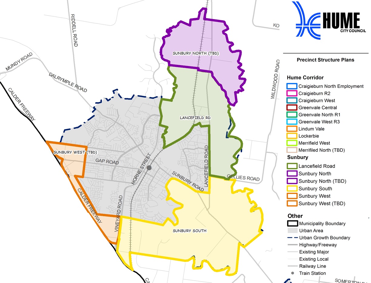
PSP Relevant to Sunbury:
Sunbury South PSP (June 2018) - updated June 2022
Lancefi Future Precinct Structure Plans to be confirmed
Sunbury West (Future PSP)
Sunbury North (Future PSP)
Precinct Structure Plan:
Acts as a roadmap for creating a high-quality urban environment
Establishes a vision for land development, outlining future urban structure and development objectives
Identifies necessary projects to ensure timely access to services and transport infrastructure for residents, visitors, and workers
Specifies the form and conditions for future land use and development
Sets the framework for development controls in the Urban Growth Zone
Guides planning permits within the zone
Offers direction for developers, investors, and local communities regarding future development
Complies with the requirements of the EPBC Act 1999
Hume Regional Growth Plan
The Hume Regional Growth Plan was published in 2014 to offer a comprehensive approach to land use planning across the Council area. Accompanied by a background paper detailing considerations, the plan outlines strategies to foster growth and facilitate change over the next three decades. Building upon the Hume Strategy for Sustainable Communities 2010–2020, it aspires to realise a shared vision for the Hume Region. The plan outlines future development locations, preservation strategies for environmental and heritage assets, and regional infrastructure priorities to support growth.
Vision of The Hume Region
The Hume Region will be resilient, diverse and thriving. It will capitalise on the strengths and competitive advantages of the four sub-regions, to harness growth for the benefit of the region and to develop liveable and sustainable communities.
Hume Council Planning Scheme (2024)
The council is responsible for ensuring adequate housing, facilities, infrastructure, and services for new residents and businesses. The city of Hume is experiencing rapid growth and to address this, the Council has continuously updated its planning scheme. The population will grow by more than 50% from just under 245,000 in 2021 to nearly 395,000 by 2041. When all current growth area land is developed the population will be around 420,000. Revisions to the plan may occur based on feedback and changes in circumstances, or new planning information.
New development has occurred in the growth areas, supported by the zoning applied by the Hume Planning Scheme and the precinct structure plans. The new urban areas are supported by new schools, parks, sporting grounds, local centres and transport infrastructure.
Sunbury Suburb Summary
References
Hume Council – PSP Locations Map
Melbourne 2030: A Planning Update
Melbourne Urban Growth boundary
Growth Corridor Plan – Managing Melbourne’s Growth
The North Growth Corridor Plan
The Sunbury Growth Corridor Plan
Melbourne outer northern suburbs to CBD capacity upgrade
Hume-Regional-Growth-Plan-May-2014
Lacefield Road Precinct Structure Plan - VPA
Sunbury South Precinct Structure Plan - VPA
Estate overview
This information is estimated by the OpenLot research team. Let us know here to provide up-to-date information about this development.
| Total new homes | |
| Area Size | N/A |
| Growth Region | Melbourne North Growth Corridor |
| City Council | Hume City Council |
| Developer | Pask |
| Project Marketer | Core Projects |
| Distance to | |
| OpenLot Offer | $200 Cashback |
Updates for Rockcliffe Estate - Sunbury

Builder overview
Hi, we’re mayde. We’re proud to be helping first home buyers in Victoria achieve their dreams by designing and building beautiful places to live. While this might be a journey of firsts for you, it’s a path we’ve trod many times before. We’re a little different from the average home designers and builders next door. We keep the process refreshingly simple and work hard to make sure it’s one you’ll love being part of. Because we believe building your first home is a journey you deserve to enjoy. Ready to build your own castle? Let’s make it happen together.
Nearby schools in Rockcliffe Estate - Sunbury
There are 6 schools registered in this area on ACARA 2024
FAQs about Rockcliffe Estate - Sunbury
Pask is the developer behind Rockcliffe Estate - Sunbury.
Rockcliffe Estate - Sunbury consists of 950 homes.
Rockcliffe Estate - Sunbury falls under Hume City Council.
Rockcliffe Estate - Sunbury is 34 km north-west of Melbourne CBD.
Core Projects is the project marketer for Rockcliffe Estate - Sunbury.
Nearby schools for Rockcliffe Estate - Sunbury:
- Salesian College Sunbury - 3.2km south-west
- Goonawarra Primary School - 3.2km south-west
- Kismet Park Primary School - 3.6km west
- Our Lady of Mount Carmel School - 3.9km south-west
- Sunbury College - 4.0km south-west
- St Anne's School - 4.6km west
Land Price Trend in Sunbury VIC 3429
Below shows the price trend from vacant land sales recorded in Sunbury VIC 3429.
The data and information provided by Terralytics (Aust) Pty Ltd (Terralytics Data) is general in nature and is not intended to constitute professional advice. Read more
It should not be relied upon as a substitute for legal, financial, valuation, or other specialist advice relevant to your specific circumstances.
Terralytics uses commercially reasonable endeavours to ensure the Terralytics Data is current and accurate. However, as the Terralytics Data incorporates information sourced from third parties, Terralytics makes no representation or warranty — express or implied — as to its accuracy, completeness, or currency. To the maximum extent permitted by applicable law, Terralytics excludes all liability for any loss or damage (including consequential loss) arising out of or in connection with reliance on the Terralytics Data, whether arising in contract, tort (including negligence), statute, or otherwise.
Popular Estates near Rockcliffe Estate - Sunbury


Not exactly what you're looking for? Try surrounding suburbs
Hillside VIC 3037
1 estate | Melton City Council
12.7km south
Plumpton VIC 3335
1 estate | Melton City Council
10.8km south-west
Bulla VIC 3428
1 estate | Hume City Council
7.8km south-east
Toolern Vale VIC 3337
1 estate | Melton City Council
13.1km west
Diggers Rest VIC 3427
9 estates | Hume City Council, Melton City Council
5.8km south
Mickleham VIC 3064
19 estates | Hume City Council
13.1km east


